For Australian local government

Every park. Maintained. Verified.

A live, GPS-verified view of every park, reserve and road corridor your contractors maintain — and a permanent audit trail for the month you have to prove it.

Hosted in AWS Sydney. Council data stays in Australia. Built in Queensland.
ParksReservesRoad corridors
Compliance map
Redland City Council · 214 sites · 4 contractors
186
Current
21
Due soon
7
Overdue
E G W Wood Sportsfield
Mown 2 days ago · Vantage Grounds
Current
Tarradarrapin Creek Wetlands
Slashing due in 3 days · Vantage Grounds
Due soon
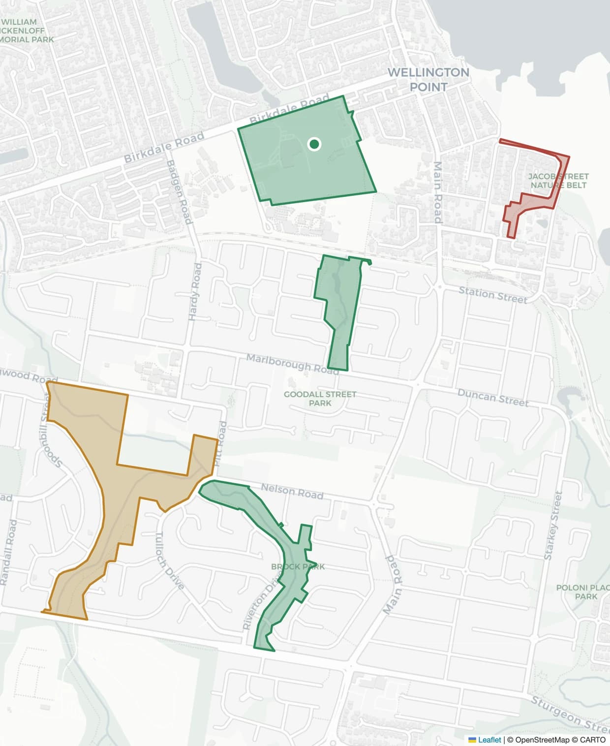
Jacob Street Nature Belt
Overdue by 6 days · Coastline Veg
Overdue
Compliance map of a coastal council area: real streets and reserves with site boundaries shaded by maintenance status — a mown point reserve current, wetlands due for slashing, and a creek corridor overdue with a crew on site.
Live · last completion 14 minutes agoUpdated 06:00 AEST
The problem

The work gets done. Proving it happened is a spreadsheet and an inbox.

01
The monthly invoice

A contractor invoices for 180 services. You approve it because you have no practical way to check that 180 services happened.

02
The resident complaint

A councillor forwards a complaint about a reserve that "hasn’t been touched in months". Finding out when it was last mown takes three emails and two days.

03
The claim

A public liability claim names a park. Your evidence that it was maintained to schedule is a spreadsheet anyone could have edited.

Why not the system you have

Your asset register knows the reserve exists. It does not know it was mown.

Councils are not short of systems. They are short of a system that treats a completed service as evidence rather than a status field somebody set.

  • Asset register

    An asset register records that the reserve exists, its area, and who holds the contract.

    Verdue

    Verdue records that it was mown on the 14th, by whom, inside the boundary, with photographs — and that the next service is due on the 28th.

  • Works orders

    A works order system closes the job when the contractor marks it closed.

    Verdue

    A completion only counts when the GPS position falls inside the site polygon. Near the park is not the park.

  • Spreadsheet

    A spreadsheet holds whatever was typed into it, whenever someone got to it.

    Verdue

    Records are immutable once submitted. Corrections are appended with their own timestamp, never written over the original.

How it works

Three steps, and only one of them is yours.

01

The crew finishes the job

Your contractor works as they always have. Their field app captures position, time and photographs on site.

Contractor side
02

Verdue verifies it

The completion is checked against the actual site boundary in PostGIS before it counts, then written to an immutable record.

Automatic
03

You see it live

The site turns green on your compliance map the moment it is verified. Overdue sites surface without anyone chasing them.

Council side
The record

The month, in one document you can hand to audit.

Not a folder of photographs. A single compliance report per month, broken down by contractor, category and zone — with every figure traceable back to the position, timestamp and photographs captured on site.

See what it covers

Monthly compliance reportRCC-2026-06
Redland City Council
Vegetation maintenance — June 2026
Generated 1 July 2026, 06:04 AEST · Immutable record
186
Services completed
4
Contractors
7
Sites overdue
Parks — Category A48 of 48 services
Reserves — Category B61 of 64 services
Road corridors77 of 81 services
Boundary-verified184 of 186 jobs

Every service in this report links back to the GPS position, timestamp and photographs captured on site. Records cannot be edited after submission — corrections are appended, never overwritten.

Audit trail

Built to be read years later, by someone who wasn’t there.

Insurance claims, legal discovery and audit requests arrive long after the crew has moved on. Every record Verdue holds is written once and kept whole.

  • Immutable once submitted
  • Corrections appended, never overwritten
  • GPS position checked against the site boundary
  • Photographs retained with the record
Plans

Three tiers, sized by how much land you manage.

Every tier includes the compliance map, boundary verification and audit-ready reporting — the tier sets the scale, not the capability. Pricing is quoted per council against your site count and contract structure.

Starter
Up to 50 sites

A single contract, or one department proving the model before it goes council-wide.

  • Sites50
  • Contractors5
  • Council users3
  • Live compliance map with status by site
  • GPS boundary verification on every completion
  • Monthly compliance report (PDF)
  • Overdue and due-soon email alerts

Enough to run one maintenance contract end to end.

Request a quote

Quoted per council · Annual agreement

Enterprise
Unlimited sites

Large or amalgamated LGAs, shared-service arrangements, and councils integrating Verdue with existing systems.

  • SitesUnlimited
  • ContractorsUnlimited
  • Council usersUnlimited
  • Everything in Professional
  • Read API for your asset or GIS system
  • Custom report templates to your contract terms
  • SSO and role mapping to your directory
  • Named implementation and support contact

Tailored to how your council already works.

Request a quote

Quoted per council · Annual agreement

Founding councils

Verdue is new. The first councils aboard shape it.

We would rather say that plainly than dress it up. Founding councils work directly with the people building Verdue — and the terms reflect it.

Ask about founding terms

  • Report templates shaped to your contract terms
  • A named contact, not a ticket queue
  • Founding pricing that holds for as long as you stay
Questions

What contract managers ask first.

All questions

Do our contractors have to change how they work?
They keep working the way they do now. What changes is how the record reaches you: instead of a photo folder and an email, their app submits a verified completion to Verdue automatically. Contractors using Stipa are connected in minutes. Contractors using something else can submit through the same interface, and contractors with no software at all can be set up with manual entry so nobody is locked out of your contract.
Where is our data stored?
In Australia. All storage, processing and email delivery happens in the AWS Sydney region (ap-southeast-2) — the same region used by the ATO, Services Australia and over a thousand Australian government agencies. The underlying AWS infrastructure holds an IRAP PROTECTED assessment. Verdue itself has not been independently assessed, and we say so plainly rather than borrowing the claim.
Does Verdue score or rank our contractors?
No, and it never will. Verdue reports factual counts and rates with the sample size beside them, and says nothing at all where the sample is too small to support a statement. Judging contractor performance requires knowledge of contract context and site difficulty that software does not have — that judgement stays with your contract manager.
How long does implementation take?
Typically four to six weeks from GIS handover to go-live. The bulk of that is importing your parks and reserves data, configuring maintenance frequencies per category, and onboarding contractors. We do that work — councils do not self-serve their way through a setup wizard.

See your own sites on the map. Book a 30-minute demo.